Getting Started with FoBE Breakout L76K
Introduction
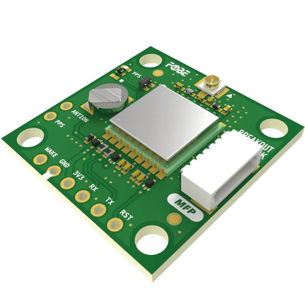
The FoBE Breakout L76K integrates the Quectel L76K multi-constellation GNSS receiver, supporting GPS, BeiDou, GLONASS, Galileo, and QZSS satellite systems. The module provides fast and accurate positioning with AGNSS support, featuring both multi-system joint positioning and single system independent positioning capabilities. Multiple connectivity options are provided for easy integration into various applications.
Applications
- Mobile applications requiring precise geolocation capabilities
- Asset tracking and fleet management systems
- Navigation and positioning devices
- IoT applications with location awareness
- Geofencing and location-based services
Key Features
-
L76K GNSS Receiver
- Multi-constellation support: GPS, BeiDou, GLONASS, Galileo, QZSS
- Multi-system joint positioning and single system positioning modes
- AGNSS (Assisted GNSS) function for faster positioning
- High-performance positioning with excellent accuracy
- Low power consumption with standby mode support
- Fast Time-To-First-Fix (TTFF) performance
- Built-in jamming detection and mitigation
- Wide operating temperature range
-
Power Management
- Built-in 3.1V rechargeable button cell battery for RTC
- Power supply: 3.3V via connector
- Low-power standby mode with wake functionality
- Reset functionality for system recovery
-
Antenna Support
- Onboard U.FL antenna connector
- Support for passive and active antennas
- Optional active antenna power supply
-
Connectivity
- MFP (JST-SH1.0 6-Pin) Interface
- Power supply (3.3V)
- UART interface for data communication
- Wake and reset control pins
- 6-Pin 2.54mm Header Holes
- MFP (JST-SH1.0 6-Pin) Interface
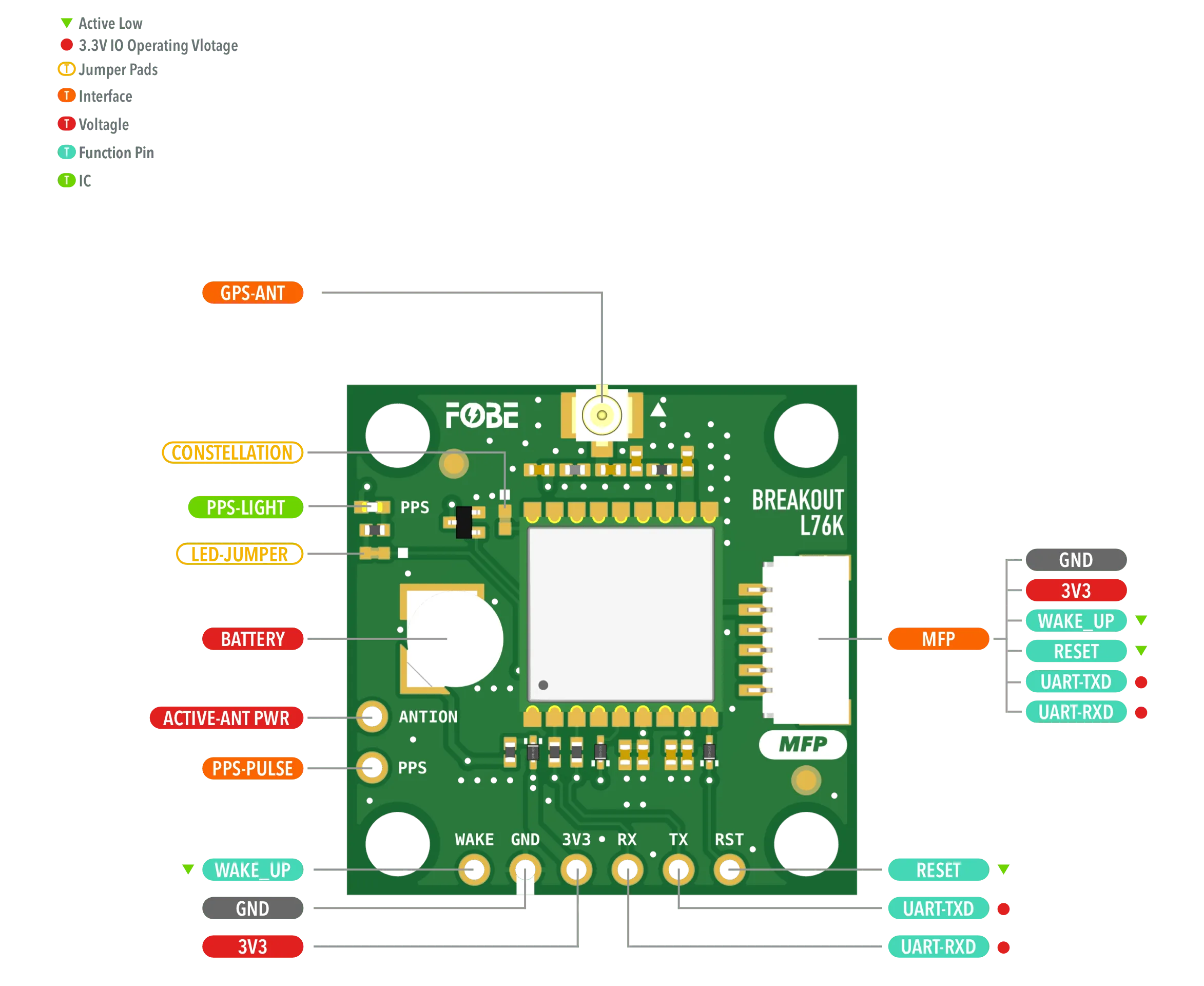
Hardware diagram
The following figure illustrates the FoBE Breakout L76K hardware diagram.
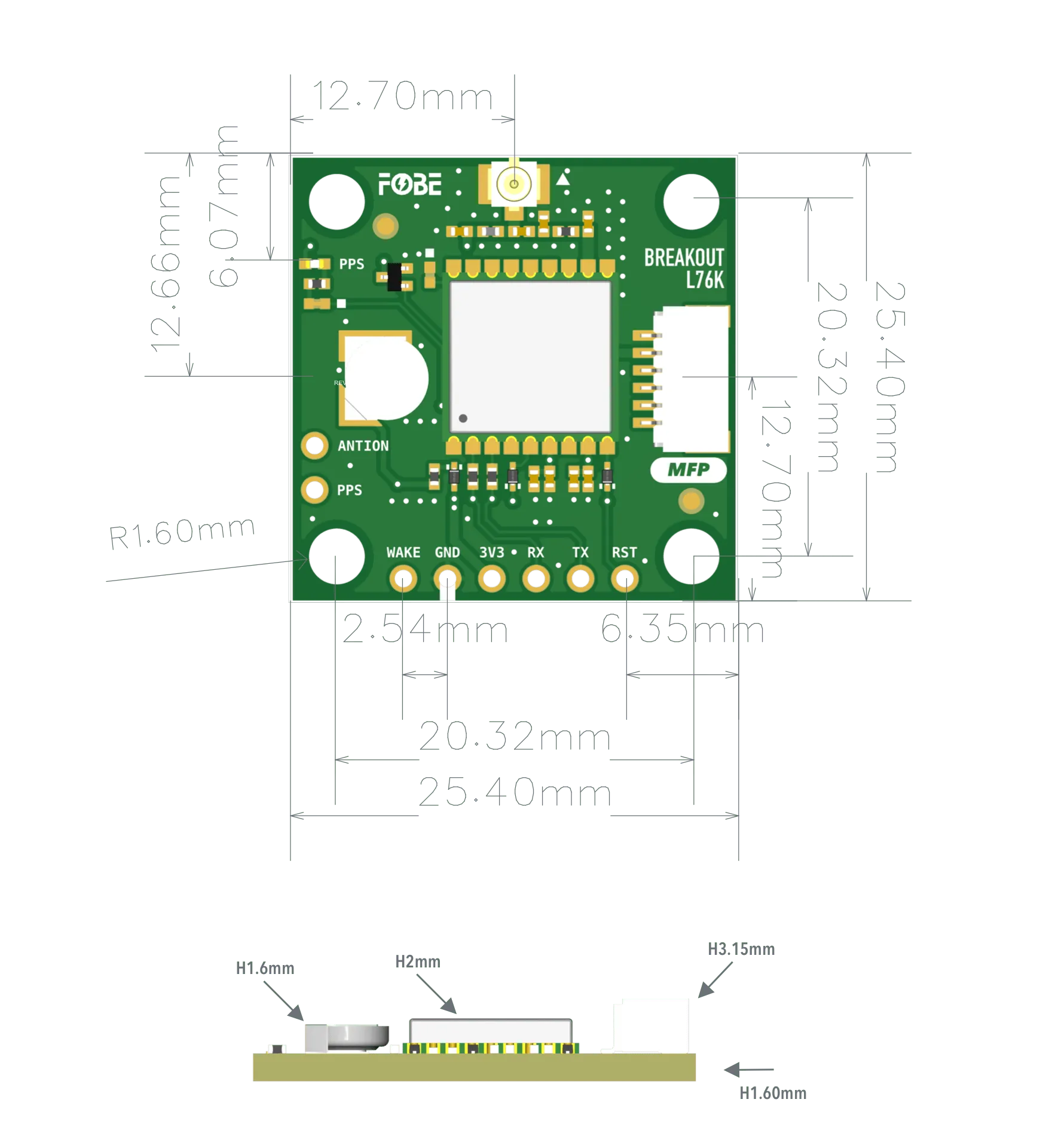
Mechanical dimensions
FoBE Breakout L76K is a single-sided 25.4mm x 25.4mm (1" x 1") 1.6mm thick PCB with a SH1.0 6-pin connector and a set of 6-pin 2.54mm header holes. Fixing by 4 x 1.6mm Screw holes.
Interfaces
The module provides a 6-Pin JST SH1.0 connector and corresponding 2.54mm header holes.
| 2.54mm 6-Pin | JST-SH1.0 | Features |
|---|---|---|
| 3V3 | 3V3 | Power supply, Only 3.3V |
| GND | GND | Ground |
| TX | TX | UART data output |
| RX | RX | UART command input |
| RST | RST | Reset IC, Active Low |
| WAKE | WAKE | Standby mode control, Active Low |
Advanced
Jumper
The module features two jumper pads:
| Interface | Description |
|---|---|
| CONSTELLATION | Satellite constellation selector:Soldered: GPS + GLONASSOpen: BeiDou + GPS (Default) |
| LED-JUMPER | Disconnect this jumper to turn off the PPS LED for further power saving |
Additional Features
- Built-in Battery: 3.1V rechargeable button cell for data retention
- Active Antenna Support: Connect "ACTIVE-ANT PWR" pad to 3V3 when using active antenna
- PPS Output: Pulse-per-second signal output, independent of LED jumper control
Programming
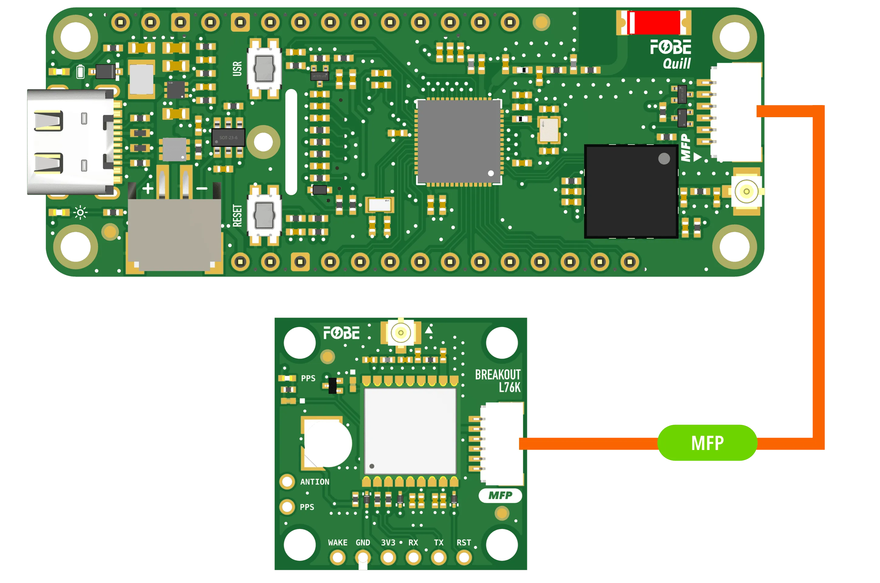
Running with FoBE Quill ESP32S3 Mesh
Let's get started with the FoBE Quill ESP32S3 Mesh using the MFP interface.
- Connect the FoBE Breakout L76K to the FoBE Quill ESP32S3 Mesh using the MFP interface.
-
Create a sketch or PlatformIO project, or follow the FoBE Quill ESP32S3 Programming Guide for pre-configuration.
-
Install the necessary library in your project:
mikalhart/TinyGPSPlus@^1.1.0
- Copy the following code into your sketch or PlatformIO project:
#include <TinyGPSPlus.h>
#include <SoftwareSerial.h>

#define GNSS_BAUD 9600          // GNSS module baud rate
#define GNSS_RX_PIN PIN_MFP1    // RX pin for GNSS communication, change if needed
#define GNSS_TX_PIN PIN_MFP2    // TX pin for GNSS communication, change if needed
#define GNSS_RST_PIN PIN_MFP3   // Reset pin for GNSS, change if needed
#define GNSS_WAKE_PIN PIN_MFP4  // Wake pin for GNSS, change if needed
#define PERI_EN_PIN PIN_PERI_EN // Peripheral enable pin, change if needed

TinyGPSPlus gnss;

// Buffer to store the latest NMEA sentence
String latestNmeaSentence = "";
char nmeaBuffer[128];
int bufferIndex = 0;

// Time tracking variables
unsigned long startupTime = 0;
unsigned long firstFixTime = 0;
bool firstFixAchieved = false;

void setup()
{
  // Initialize serial communication
  Serial.begin(115200);
  Serial.println("Serial initialized");

  // Initialize peripheral power
  if (PERI_EN_PIN >= 0)
  {
    pinMode(PERI_EN_PIN, OUTPUT);
    digitalWrite(PERI_EN_PIN, HIGH); // Enable peripheral power
    Serial.println("Peripheral power enabled");
  }

  // Initialize GNSS module (optional, if you want to test searching time cost)
  pinMode(GNSS_RST_PIN, OUTPUT);
  pinMode(GNSS_WAKE_PIN, OUTPUT);
  digitalWrite(GNSS_RST_PIN, LOW); // Reset the GNSS module
  delay(100);
  digitalWrite(GNSS_RST_PIN, HIGH);  // Release reset
  digitalWrite(GNSS_WAKE_PIN, HIGH); // Wake the GNSS module

  Serial1.begin(GNSS_BAUD, SERIAL_8N1, GNSS_RX_PIN, GNSS_TX_PIN);
  Serial.println("GNSS bus initialized");

  // Wait a moment for module to fully initialize
  delay(200);

  // Record startup time
  startupTime = millis();
  Serial.printf("Startup time recorded: %lu ms\n", startupTime);

  // Wait for GNSS to be ready (equivalent to sensor init loop)
  Serial.println("Waiting for GNSS data...");
  unsigned long startTime = millis();
  while (millis() - startTime < 10000) // Wait up to 10 seconds
  {
    while (Serial1.available() > 0)
    {
      gnss.encode(Serial1.read());
    }
    if (gnss.location.isValid() || gnss.time.isValid() || gnss.satellites.value() > 0)
    {
      break;
    }
    delay(200);
  }

  // Configure GNSS settings, calculate checksum reference https://www.hhhh.org/wiml/proj/nmeaxor.html
  Serial1.write("$PCAS04,7*1E\r\n"); // Configure satellite constellation
  delay(250);
  Serial1.write("$PCAS11,3*1E\r\n"); // Configure positioning mode
  delay(250);
  Serial1.write("$PCAS03,1,0,0,0,1,0,0,0,0,0,,,0,0*02\r\n"); // Configure positioning frequency
  delay(250);
  Serial1.write("$PCAS02,200*1D\r\n"); // Configure positioning frequency
  delay(250);

  Serial.println("GNSS sensor initialized");

  // Start measurement (GNSS automatically starts after initialization)
}

void loop()
{
  delay(50); // Wait equivalent to gnss.wait()

  // Read data from GNSS (equivalent to gnss.update())
  bool dataUpdated = false;
  while (Serial1.available() > 0)
  {
    char c = Serial1.read();

    // Build NMEA sentence buffer
    if (c == '$')
    {
      bufferIndex = 0;
      nmeaBuffer[bufferIndex++] = c;
    }
    else if (bufferIndex > 0 && bufferIndex < 127)
    {
      nmeaBuffer[bufferIndex++] = c;
      if (c == '\n')
      {
        nmeaBuffer[bufferIndex] = '\0';
        latestNmeaSentence = String(nmeaBuffer);
      }
    }

    if (gnss.encode(c))
    {
      dataUpdated = true;
    }
  }

  if (dataUpdated) // Equivalent to gnss.update() == RESULT_OK
  {
    if (gnss.location.isValid() || gnss.time.isValid()) // Equivalent to gnss.hasNewData()
    {
      // Check for first fix achievement
      if (!firstFixAchieved && gnss.location.isValid())
      {
        firstFixTime = millis();
        firstFixAchieved = true;
      }

      // Display data on screen
      Serial.print("\033[H\033[J");
      Serial.println("> FoBE Breakout L76K Monitor");
      Serial.println();
      Serial.print("\033[7m");
      Serial.printf("%-12s%-12s%-12s\n", "INDEX", "VALUE", "UNIT");
      Serial.print("\033[0m");

      if (gnss.location.isValid())
      {
        Serial.printf("%-12s%-12.6f%-12s\n", "LATITUDE", gnss.location.lat(), "°");
        Serial.printf("%-12s%-12.6f%-12s\n", "LONGITUDE", gnss.location.lng(), "°");
      }

      if (gnss.altitude.isValid())
      {
        Serial.printf("%-12s%-12.2f%-12s\n", "ALTITUDE", gnss.altitude.meters(), "m");
      }

      if (gnss.speed.isValid())
      {
        Serial.printf("%-12s%-12.2f%-12s\n", "SPEED", gnss.speed.kmph(), "km/h");
      }

      if (gnss.satellites.isValid())
      {
        Serial.printf("%-12s%-12d%-12s\n", "SATELLITES", gnss.satellites.value(), "");
      }

      if (gnss.hdop.isValid())
      {
        Serial.printf("%-12s%-12.2f%-12s\n", "HDOP", gnss.hdop.hdop(), "");
      }

      // Add GPS time display
      if (gnss.time.isValid() && gnss.date.isValid())
      {
        Serial.printf("%-12s%02d:%02d:%02d%-12s\n", "TIME", gnss.time.hour(), gnss.time.minute(), gnss.time.second(), "UTC");
        Serial.printf("%-12s%04d-%02d-%02d%-12s\n", "DATE", gnss.date.year(), gnss.date.month(), gnss.date.day(), "");
      }

      // Add Time to First Fix Information
      if (firstFixAchieved)
      {
        unsigned long timeToFirstFix = firstFixTime - startupTime;
        Serial.printf("%-12s%-12.3f%-12s\n", "TTFF", timeToFirstFix / 1000.0, "SEC");
      }
      else
      {
        unsigned long currentTime = millis();
        unsigned long timeElapsed = currentTime - startupTime;
        Serial.printf("%-12s%-12.3f%-12s\n", "SEARCHING", timeElapsed / 1000.0, "SEC");
      }

      // Print latest NMEA data stream below the table
      Serial.println();
      Serial.println("Latest NMEA Data Stream:");
      if (latestNmeaSentence.length() > 0)
      {
        Serial.print(latestNmeaSentence);
      }
      else
      {
        Serial.println("No NMEA data received yet");
      }
    }
  }
}
This example code uses ANSI output formatting. Your terminal must support ANSI escape codes to display the output correctly.
# platformio.ini
[env:fobe_quill_esp32s3_mesh]
platform = FoBE Espressif 32
board = fobe_quill_esp32s3_mesh
framework = arduino
lib_deps =
	mikalhart/TinyGPSPlus@^1.1.0
monitor_speed = 115200
monitor_raw = true
- Build and upload the project. You should see the FoBE Breakout L76K Monitor output in the serial monitor (raw mode).
> FoBE Breakout L76K Monitor

INDEX       VALUE       UNIT
LATITUDE    22.123456   °
LONGITUDE   114.123456  °
ALTITUDE    71.20       m
SPEED       17.33       km/h
SATELLITES  15
HDOP        24.80
TIME        19:59:03UTC
DATE        2025-08-08
TTFF        3.236       SEC

Latest NMEA Data Stream:
$GNGSA,A,1,,,,,,,,,,,,,25.5,24.8,25.5,1*0D
Resources
[PDF] FoBE Breakout L76K Datasheet
[PDF] FoBE Breakout L76K Schematic